Training for the Impossible, Two Summers at a Time
GREENLAND ON KITES
Parler
The Long Way to Antarctica
When french adventurer Matthieu Tordeur called to ask if I wanted to cross Antarctica by kite ski, there was just one catch: I had never kited in my life. What followed were two summers in Greenland — 2024 and 2025 — learning a completely new discipline on some of the most demanding terrain on Earth, while simultaneously collecting scientific data on the ice sheet. This is the story of both expeditions: from the crevasse fields above Ilulissat to the ghost station of DYE-2, from near-hypothermia in the southern fog to a near-miss in a canyon above Qaanaaq. Two traverses, thousands of kilometres, and a great deal still to come.
Parler
GREENLAND ON KITES
A PHONE CALL THAT CHANGES EVERYTHING
A few years ago, Matthieu Tordeur called me with a proposal that was either visionary or completely mad — possibly both. He wanted to cross Antarctica by kite ski. He wanted me on the team and lead the scientific programme on the expedition. There was one problem: I had never kite-skied in my life. I had never kite-surfed either. I had, in fact, never held a kite of any kind with the intention of letting it pull me anywhere.
I said yes.
What followed was many months of intensive training — in France, in Norway, Svalbard and alongside some of the most experienced kite practitioners on Earth. Kite skiing is deceptively technical. The kite is not simply a sail: it is a dynamic, three-dimensional system that must be flown with constant attention, reading the wind, anticipating gusts, managing lines that can tangle in ways that range from inconvenient to ridiculous. Progress came, but slowly. Every session taught me something new, and every new thing I learned revealed three more things I had not yet understood.
The plan was to use Greenland as a proving ground — twice, in two consecutive summers — before the Antarctica attempt. Not only to build kiting skills, but to answer a question that mattered scientifically: could serious research data be collected while kite skiing across a polar ice sheet? We intended to find out.

THE CREVASSE CORRIDOR
Our entry onto the Greenland Ice Sheet placed us close to Sermeq Kujalleq — Jakobshavn Glacier — and this was not incidental. It was also not comfortable.
Sermeq Kujalleq is one of the fastest-flowing glaciers on Earth, moving at several tens of metres per day. It drains roughly six to seven per cent of the entire Greenland Ice Sheet toward the ocean — an enormous share of a vast system, all funnelled through a single outlet. The consequence of that velocity is that the ice in this region is under enormous stress, fractured, and intensely crevassed. Some crevasses are visible. Many are not.
Before departure, Matthieu and I had defined waypoints carefully, tracing a narrow corridor of slower-moving ice that would allow us to gain altitude heading east as quickly as possible. We gave ourselves one firm rule: stay between 2,200 and 2,500 metres of elevation, where the ice is slower and the crevassing that characterises the lower margins of the glacier is left behind or buried under meters of snow.
The first day of kiting was, to be honest, type 2 fun. I was just coming out of months of pneumonia. My fitness was the lowest it has been for a while. And my kiting abilities were not much higher.
The technical demands hit immediately. Kite loops — a basic manoeuvre for experienced practitioners — were required almost from the start to generate power in wind that was not blowing from the direction we needed. I had not mastered kite loops. I had barely practised them. We were also hemmed in by supraglacial lakes — meltwater pools that sit on the ice surface in summer — and the altitude gain we desperately needed was stubbornly slow. Every metre of elevation felt earned.
But after a few days, we broke through.


INTO THE WHITE
Reaching cruising altitude changed everything.
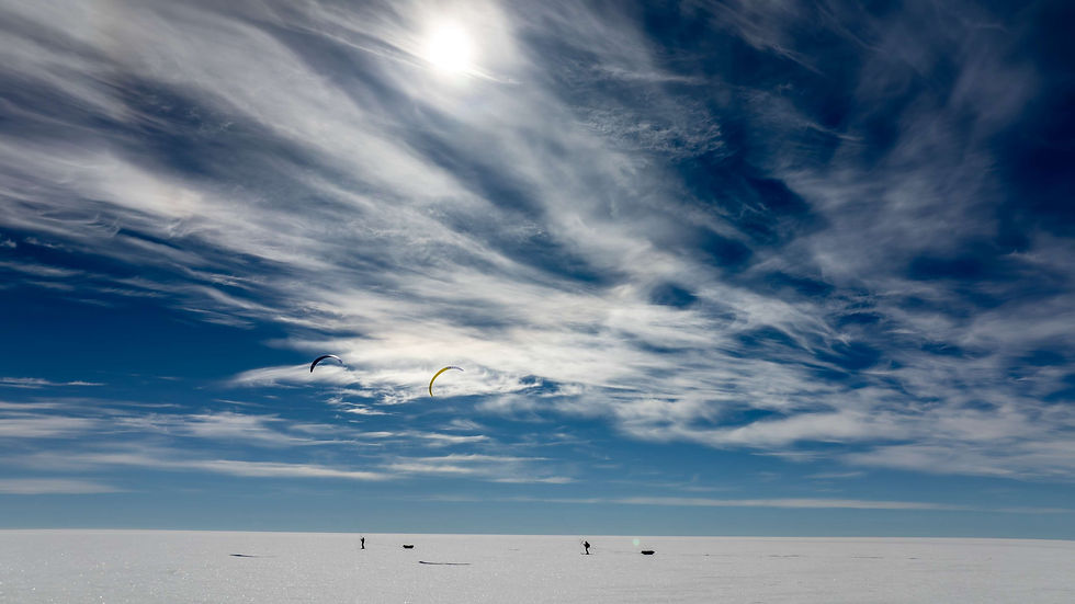
At around 2,200 metres, the terrain flattened, the crevasses disappeared beneath us, and the wind swung to our backs. We turned north, and suddenly the ice sheet became how I remembered it to be before I understood how hard the approach would be: flat, white, immense, silent except for the sound of skis on snow and the low pull of the kites overhead.
The snow surface was extraordinary. A thin layer of fresh snow over a firm base made for conditions as close to perfect for kite skiing as I can imagine — smooth, consistent, fast. The pulkas — our sleds, each carrying over a hundred and twenty kilos of equipment and supplies — glided behind us almost effortlessly. The world contracted to a few simple elements: wind, snow, horizon, and the constant attention required to keep the kite flying correctly.
I was still learning. Every hour in those conditions taught me techniques I had not had the opportunity to practise during training: how the kite behaves differently as wind speed changes, how to read the subtle shifts in surface texture that indicate a change in snow density beneath, how to stay relaxed in the harness over hours of sustained effort. Progress as a kite skier is not linear — it comes in sudden jumps of understanding, moments when something that was mechanical becomes instinctive. Several of those moments happened out there on the high plateau.
Around a week into the expedition, we saw the halos.


ILULISSAT AND THE EDGE OF THE ICE
We arrived at the end of June 2024, and spent several days in Ilulissat before the expedition began.
Ilulissat sits on the shore of Disko Bay in West Greenland and is listed as a UNESCO World Heritage Site, for reasons that become immediately obvious the moment you see it. The Ilulissat Icefjord — connected to the glacier Sermeq Kujalleq in Greenlandic — is one of the most productive glaciers on Earth, calving vast quantities of ice into the bay in a near-constant procession. The icebergs that drift past the town are monuments: some taller than buildings, some the size of city blocks, all of them luminously, impossibly blue-white in the Arctic light.
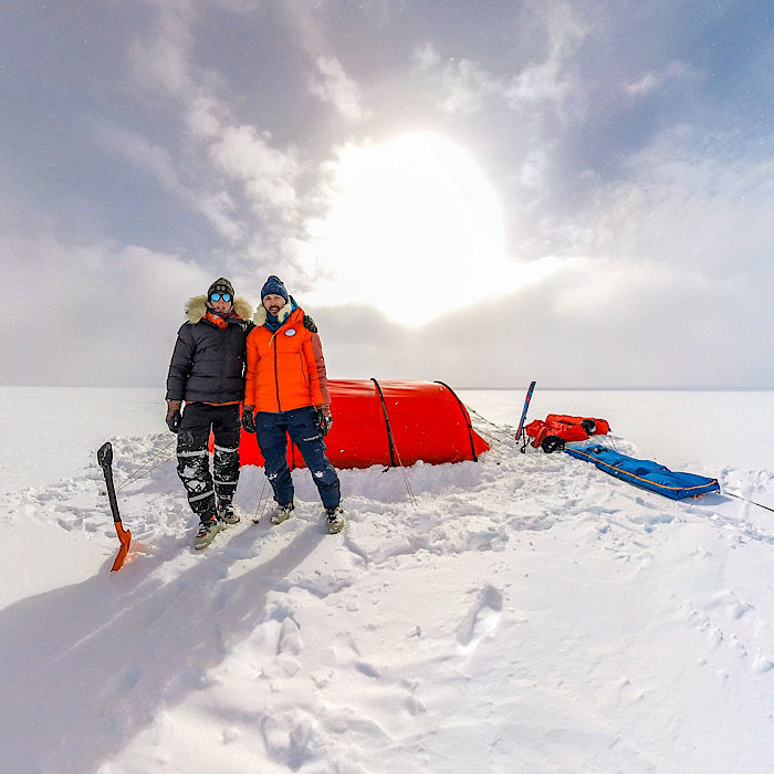
We went to the UNESCO site several times. We also spent those days doing the unglamorous but essential work that precedes every expedition: sourcing fuel, buying food, checking and rechecking scientific equipment. We carried two scientific objectives onto the ice — snow density measurements at regular intervals, and the collection of snow samples to be analysed later for black carbon concentration. Neither mission was trivial. Both were achievable, if conditions allowed.
We waited for the weather. On June 28, 2024, we started.


THE EYE OF GREENLAND
Solar halos are an optical phenomenon produced when sunlight refracts through ice crystals suspended in the atmosphere. On the plateau, under the right conditions, they form complete rings around the sun — luminous circles of light, sometimes accompanied by additional arcs and pillars, that can fill the entire sky. We stood and stared. It felt, out there with nothing around us for hundreds of kilometres in every direction, as though Greenland itself was looking back.
The halo did not last. Over the following days, as we pushed further north, the weather deteriorated. Whiteout conditions — in which cloud and snow surface merge into a single undifferentiated grey — made navigation increasingly demanding. On the ice sheet, a whiteout is not simply uncomfortable. It removes all visual reference for the ground, making it impossible to judge slope, texture, or obstacle. You navigate by GPS and by feel.
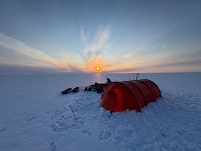
On one day when the wind dropped entirely, we stopped and worked. Matthieu and I dug a double snow pit — a side-by-side excavation that allows comparison of the snowpack structure across a small horizontal distance — recording the layering, density, and temperature of the snow at depth. We collected snow samples, which Matthieu melted and filtered on-site, preserving them for later black carbon analysis. In the silence of the windless ice sheet, the science felt very clear and very important: this is why we came.


THE DESCENT, THE WAIT, THE CANYON
On July 12, after days of difficult navigation in poor visibility, we made the major turn toward Qaanaaq — the next most demanding navigational challenge of the expedition. The route required us to follow a ridge that was invisible on the ground but clearly defined on satellite imagery and topographic maps.
Then the weather cleared.
Mountains appeared on the horizon — dark, solid shapes against the white sky. We had tears in our eyes and in our voices. After two weeks on the ice, the sight of rock meant we were approaching the margin of the ice sheet. We were nearly through. Euphoria lasted about twenty minutes.
As we descended, the snow rapidly deteriorated. Firm ice gave way to slush, then to mush, thick and waterlogged, which dragged at the pulkas and made kiting increasingly precarious. The first crevasses appeared, then meltwater channels that had to be crossed carefully, one at a time. I made the decision on the last few kilometres to put the kite down and drag my skis by hand rather than risk a fall or injury so close to the finish — the kind of accident that happens at the end of expeditions, when concentration slips and fatigue takes over.
We camped on the margin of the ice sheet, eight kilometres from the fjord. And then we waited.
A boat could only reach us when the sea ice in the fjord had cleared enough to navigate. Our weather router Mark was sending daily forecasts, and friends at home — Nina and Yann among them — were monitoring satellite images of the ice conditions on our behalf. It could be a few days or a few weeks. We had food. We started shuttling equipment toward the coastline on foot, carrying 25 to 30 kilos at a time, covering two kilometres per carry and returning for more — quadruple carries, four times the distance walked.
The second day of shuttling nearly ended very badly. We set off without reconnoitring the route first — a mistake — in near-total fog, following GPS points copied from a friend. The points led us into a canyon. The canyon deepened. The walls became steep and the path narrowed until we found ourselves standing at the edge of a waterfall — at least fifty metres high — with full packs on our backs, zero visibility, and no obvious way forward or back. Potential polar bear territory, cliffs, a large waterfall, and heavy equipment: everything you do not want simultaneously. We quickly realised our GPS coordinates were off.
A friend, reached by satellite phone, sent us corrected GPS coordinates. We found the right path.
Looking back, I would not recommend following GPS points (that on top of that were wrong) into fog without a prior recce. On that day, we were fortunate.
After a few more days of shuttling, the sea ice cleared. On July 18, 2024, a boat appeared in the fjord. It was one of the happiest moments of the expedition. We were taken to Qaanaaq.


BACK SOUTH: QAQORTOQ 2025
Qaanqaaq, one of the northernmost inhabited settlements on Earth — gave us a couple of days of rest, equipment maintenance, and reflection. The 2024 expedition had answered some questions and raised others. We had proved that snow density measurements and black carbon sampling were feasible while kite skiing. We had learned, precisely and at times painfully, what the limits of that science were in difficult conditions. We were more confident in the kites. We were not yet ready for Antarctica.
So we prepared for a second year.
In August 2025, we arrived in Qaqortoq, in southern Greenland — a very different landscape from the high Arctic plateau. This time, we carried a 60-metre deep ground-penetrating radar built by Blue Ice Systems, designed to image the internal structure of the snowpack and the ice beneath. Our route ran from Qaqortoq to Kangerlussuaq, roughly six to seven hundred kilometres, in approximately ten days if conditions permitted.
Conditions did not permit.
Southern Greenland in summer is warmer, wetter, and more unpredictable than the high plateau. From the first days, we were kiting in fog so thick and so humid that ice crystals formed on the kites and lines, adding weight and making the kites sluggish in the light winds we were dealing with. Then came the rain.
I remember one particular day in detail. I was completely drenched through every layer of clothing, all the way down to the base layer, and I could feel the cold beginning to reach the core of my body. I told Matthieu that if we stopped again, we would have to pitch the tent immediately. Kiting with the wind behind me kept me warm enough. The moment I slowed or stopped, the wind pulled the heat from me faster than my body could replace it. We pitched the tent. I stripped off the wet clothes, pulled on dry layers, and spent a couple of hours drinking hot water inside my sleeping bag. It was a close call.
The next morning brought unexpected sunshine. We laid everything outside to dry — sleeping bags, clothing, kites, lines — and what followed became one of our best days of the expedition: good conditions, fast progress, the radar collecting data cleanly as we pulled it across the plateau. We had proved that ground-penetrating radar could be operated while kite skiing. The batteries presented challenges that we carefully noted for improvement. But the concept worked.


THE NIGHT RUN
A few days later, the daytime heat made kiting impossible. The snow had softened to the point where pulling the radar sled was like dragging it through wet sand. We decided to wait for evening, when temperatures dropped and the wind typically picked up, and kite through the night.
We set off at around eight or nine in the evening with a target of ninety kilometres.
What followed was one of the most extraordinary nights of my life.
The midnight sun had set in this part of Greenland, and for long stretches we were kiting in near-darkness. We could not see the snow surface beneath our skis. We could barely see each other. Navigation meant checking the GPS regularly, choosing a cloud on the horizon to aim toward, and trusting the compass heading between checks. We stayed close, waited for each other at intervals, kept moving. The night went on and on. Northern lights appear to keep us awake.
Around three or four in the morning, something appeared on the horizon.
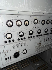
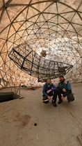
DYE-2 is a former United States Air Force radar station, built as part of the Distant Early Warning Line during the Cold War and abandoned in 1988. It sits on the Greenland Ice Sheet at approximately 2,100 metres elevation: a large elevated structure on stilts, rising from the flat white in complete isolation. Having kited through darkness for hours, seeing it emerge from the night sky was overwhelming. We were laughing. The dawn was just beginning to touch the horizon.
We found the entrance after several hours of searching — a door nearly buried in snow that required crawling through to enter. What was inside was a place frozen in time: equipment, furniture, the details of daily life, all left exactly as they were in 1988, preserved by decades of cold. It felt like stepping into a photograph. Eerie and extraordinary in equal measure — the best piece of urban exploration I have ever done, and the first.
On one wall, we found messages left by previous expeditions. Among them was a message from Dixie Dansercoer, the Belgian polar explorer who made multiple kite-ski crossings of Greenland and Antarctica before his death in 2021. Reading his words, in that frozen building on the ice sheet he too had crossed by kite, was quietly emotional.


WATER SKIING
We rested for a few hours, then set off again in the afternoon, changing direction toward Kangerlussuaq. Almost immediately, we began losing altitude.
The next morning, the snow was gone in any meaningful sense. A thin crust of ice over a completely saturated snowpack broke the moment you put weight on it, leaving you standing in liquid water. Supraglacial lakes appeared in every direction. Pulling the radar sled was close to impossible. We were no longer skiing across ice. We were, in the most literal sense, water skiing.
We pushed for another couple of days, threading between lakes and saturated sections, trying to gain ground toward the coastline. Eventually, I got stuck in a lake, with water to my thights. Skis blocked under the ice and kite pulling me the other way. The conditions decided for us. We called for a pickup.
On August 24, 2025, we reached Kangerlussuaq — the town at the head of one of the longest fjords in Greenland, and the endpoint of more polar expeditions than I can count. The feeling of arrival was one of relief as much as triumph.
Two summers. Two traverses. The ground-penetrating radar had worked. The black carbon samples were collected. The data was in the hands of the scientists who needed it. And we had learned, in the most direct way possible, what kite skiing across a polar ice sheet actually demands — in terms of skill, endurance, equipment, and judgment.
After Kangerlussuaq, I returned to Ilulissat for a few more weeks, teaching a course on climate change — a reminder, if one were needed, of why all of this matters. Then I went home to prepare for what comes next.
Antarctica is waiting.


