
Joining Alex Honnold on National Geographic's Arctic Ascent
EAST GREENLAND 2022

INTRODUCTION
Six Weeks in Greenland
In the summer of 2022, I joined climber Alex Honnold, Hazel Findlay, Aldo Kane, Mikey Schaefer, and Adam Kjeldsen for a six-week expedition into East Greenland's Scoresby Sund — the largest fjord system in the world. The goal for our elite climbers was Ingmikortilaq, a 1,400-metre cliff and one of the tallest unclimbed natural walls on Earth. My goal was different: to collect scientific data on behalf of twelve research institutes across glaciers, rock faces, ice caps, and fjords — in one of the most remote and rarely visited corners of the Arctic. The expedition became the National Geographic series Arctic Ascent with Alex Honnold, streaming on Disney+ and Hulu. This is what happened off camera.
Discover the expedition
EAST GREENLAND 2022
AN UNLIKELY TEAM
There are not many expeditions where the glaciologist is the least athletic person on the team — and knows it.
When Plimsoll Productions first approached me about joining a National Geographic expedition to East Greenland with Alex Honnold, Hazel Findlay, Aldo Kane, Mikey Schaefer, and Adam Kjeldsen, my role was clear: I was there for the science, not the climbing. What followed over six weeks was one of the most ambitious, exhausting, and extraordinary experiences of my career.
Arctic Ascent was, on the surface, a climbing expedition with the finest climbers alive. Alex, Hazel, Aldo and Mikey had set their sights on Ingmikortilaq, a 1,400-metre cliff in East Greenland, one of the tallest unclimbed natural walls in the world. But from the moment I joined the team, we agreed on something important: if we were going to this remote, scientifically precious corner of the Arctic, we were going to do proper science while we were there.
Twelve research institutes trusted me to collect data on their behalf. More than eighteen research protocols defined our scientific mission. From glaciers and rock faces to fjords and ice caps, we intended to leave no stone — or ice core — unturned.


BUILDING THE SCIENCE PLAN
An expedition of this scope does not just happen. The research plan for Arctic Ascent was carefully crafted with marine biologist Harry Gunning and science communication expert Roshan Salgado D’Arcy — two people whose rigour and creativity shaped what became an ambitious, multidisciplinary programme.
The goal was science that was bombproof, ambitious, and genuinely valuable to the scientific community. Not science done for the cameras. Science done because this part of the Arctic is rarely visited by researchers, and every visit represents an opportunity that should not be wasted.
A week before the main team arrived, I flew to Nerlerit Inaat — the small airport at Scoresby Sund — with Rosie Gloyns from Plimsoll, Aldo Kane, and Adam Kjeldsen. Our job was to inspect all the scientific equipment, install the instruments that needed time to collect data, and get familiar with what lay ahead. We practiced bear and musk ox safety protocols, sorted the camping equipment, and adapted — quickly — to the intense mosquito welcome that East Greenland delivers every summer without fail.
Then the rest of the team arrived, and the expedition began in earnest.


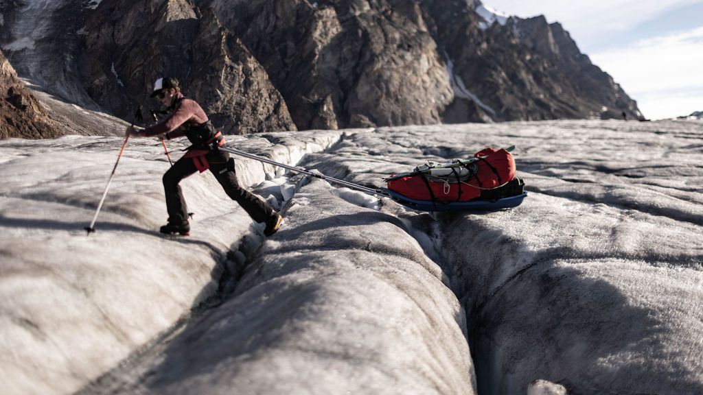
INTO THE ICE: THE EDWARD BAILEY GLACIER
Our first objective was the Edward Bailey Glacier, reached by hiking up the lower part of the Apusinikajik Glacier from the coast. The surface was dotted with blue lakes, wide river channels, and crevasses hidden beneath deceptively innocent snow bridges. Between the two glaciers, we crossed what felt like a small desert: dry glacial flour and a dusting of red mineral particles that gave the landscape an almost alien quality.
The scientific focus here was moulins.
Moulins are deep vertical shafts in the glacier surface, formed when meltwater bores downward through the ice, channelling vast quantities of water from the surface to the glacier bed far below. They are scientifically important because what happens at the base of a glacier — the lubrication, the pressure, the movement — is directly influenced by how much water reaches it from above. In a warming climate, with more surface melting, moulins become larger and more numerous. Understanding them helps us understand how quickly glaciers will flow toward the sea.
In summer, a large moulin makes a sound like nothing else: a deep, continuous roar, audible hundreds of metres away. We used every instrument we had to locate them, initially without success. Then the sound gave them away.
Finding a sizable moulin was a relief — and then immediately came a major setback. The primary instrument I had brought for 3D mapping of the moulin interior, which had been tested before departure, refused to function in the field. After lengthy satellite phone calls with the manufacturer, it became clear that nothing could be fixed remotely. We adapted, worked with what we had, and — with Aldo Kane’s expertise securing the safety of the operation — completed our first major scientific mission. Science in the field rarely goes exactly to plan. What matters is what you do when it doesn’t.


THE PLACE
East Greenland’s Scoresby Sund is the largest fjord system in the world. That superlative does not quite prepare you for what it actually looks like.
The fjords are extraordinarily deep, the mountains remarkably steep and tall, the glaciers truly colossal. Standing at sea level and looking up, everything is on a scale that the human eye struggles to process — as if the landscape was designed for a different species. I had visited East Greenland more than six years earlier, but returning was still a shock. The vastness, the untamed power of it, the beauty: it hits you in the chest.
It also hits you as something worth protecting. This region is changing faster than almost anywhere else on Earth. What we were about to study was not abstract data — it was the accelerating transformation of a place of staggering importance for the entire planet.


POOL WALL
From the Edward Bailey Glacier, we arrived at Pool Wall: 450 metres of sheer gneiss rising from a turquoise pool at its base, which gives the feature its name. Seen from base camp, it was simultaneously beautiful and terrifying — steep and overhanging, the kind of wall that makes you grateful to be a glaciologist.
We spent a week at this location. For the climbers, it was time to study the wall, plan their lines, and begin the ascent. For me, it was time to prepare one of the more physically demanding parts of the science programme: while I was not supposed to join anyone on the wall and ski around it, turns out that climbers can be convincing. I found myself agreeing to collect the rock samples I needed myself, with the tremendous help of everyone. It took some logistics. And drills and heavy drill bits. The samples would allow researchers to date the surface exposure of the rock — to understand when this face was last covered by ice, and how the glacier that once filled this valley has retreated over time.
The only way to collect those samples was to go where the rock was. And the rock was vertical.
Working with the world’s best climbers makes things that sound impossible merely very difficult. Watching Alex and Hazel move up Pool Wall was, as one team member put it, like watching a film — the grace, the strength, the calm decision-making at extreme height. The professionalism of the entire team, both on the wall and behind the cameras, made this one of the finest collaborative efforts I have ever been part of.


THE RENLAND ICE CAP
From the top of Pool Wall, the next challenge came into view: the Renland Ice Cap, a plateau of snow and ice perched on the edge of the Greenland Ice Sheet.
Renland occupies a scientifically fascinating position. As a peripheral ice cap — separate from, but adjacent to, the main Greenland Ice Sheet — it responds to climate change in ways that allow researchers to “see things coming.” Changes that will eventually affect the main ice sheet often show up first in smaller, more sensitive ice masses like Renland. Studying it means reading signals that are relevant far beyond this single location.
Our primary mission on Renland was to collect Ground Penetrating Radar data. Pulling two heavy radars across the ice cap on skis, we mapped the thickness of the snow and ice at continuous intervals — data that feeds into broader models of how much frozen water is locked up in Greenland’s peripheral ice, and how fast it is being lost. Adam Kjeldsen pulled the second radar throughout, with patience and stamina that I remain genuinely in awe of.
We also dug snow pits — excavating into the snowpack to study its density, layering, and structure. Alex Honnold and Hazel Findlay, when not climbing, joined us for this work. There is something quietly remarkable about digging snow pits with one of the world’s greatest climbers. The science does not care who is holding the shovel.
No team had ever skied across the Renland Ice Cap before. We did it collecting data the entire way, in cold and wind, camping on the ice. The descent to sea level involved pulling pulkas over unstable terrain, leaping crevasses, and navigating menacing ice cliffs. It was type 2 fun in the truest sense — not enjoyable at the time, deeply satisfying in retrospect.


THE FJORD
At sea level, a different world opened up. Three individuals from the village at the mouth of Scoresby Sund — Aqqalu, Rene, and Maratsi — met us with their fast boats, and suddenly our expedition had a new dimension: the fjord itself.
Nord Vest Fjord is a place of legends. Towering mountains, colossal drifting icebergs, and the sheer scale of the Greenland Ice Sheet visible at the head of the system — it is overwhelming in the best possible way. The calm water, the reflections, the silence broken only by the occasional crack and thunder of calving ice: it is not a place that leaves you unchanged.
We had scientific work to do here too. One of our key missions was to launch a specialised instrument into the waters of the fjord for NASA’s Oceans Melting Greenland project — a programme studying how warm ocean water is eating into the base of Greenland’s glaciers from below, a process that contributes significantly to sea-level rise. The instrument would measure water temperature and salinity at depth, adding data to a growing picture of how the ocean and the ice sheet interact beneath the surface.
Then we turned toward Ingmikortilaq.


INGMIKORTILAQ
The final chapter of the expedition was the one the whole project had been built around: a 1,400-metre cliff, one of the tallest in the world, rising straight from the fjord.
We established base camp in an extraordinary spot — a flat, sheltered area between the fjord and a small bay, surrounded by musk oxen, foxes, blueberry bushes, and the slow procession of icebergs drifting past. For a brief moment, it felt like paradise. Then the work began.
While Alex and Hazel committed to the wall, I focused on the science programme with Adam: time-lapse photography of the icebergs in the fjord, three-dimensional mapping of iceberg geometry, and preparation and installation of thermistor strings — chains of temperature sensors placed on the rock face to measure how the wall heats and cools through the day, feeding into research on rock weathering and slope stability in Arctic environments.
Installing those sensors on a 1,400-metre cliff required people who were comfortable in places most are not. Aldo Kane and Mikey Schaefer did that work — ascending the wall to place the sensors in conditions I can only describe as treacherous, with the quiet competence that characterises everything they do.
From a small boat on the fjord below, I watched Alex and Hazel make their way up the wall. At that scale, they were tiny figures — ants against an almost incomprehensible expanse of grey rock. Watching them move, watching the precision and courage required for every metre of progress, I felt something close to disbelief that human beings are capable of this.
What happened on that wall, I will leave for the film to show. Some things are better witnessed than described.


WHAT IT ALL MEANT
Arctic Ascent began in August 2021 — more than two years of preparation, coordination between scientists, filmmakers, climbers, logistics teams, and research institutions, before a single boot hit East Greenland ice.
When it was over, what we had assembled was a dataset spanning glaciology, oceanography, geology, and atmospheric science — collected from one of the most remote and rarely visited corners of the Arctic, by a team that brought together skills not usually found in the same place at the same time.
The science matters. The film matters too — not as decoration, but because the images and stories that reach people’s living rooms have a power that journal papers rarely achieve. If Arctic Ascent makes even a fraction of its audience understand what is at stake in the Arctic — why the health of this region is inseparable from the future we all share — then the six weeks of cold, effort, and occasional equipment failure were well spent.
“If we lose the Arctic, we lose the world.”
I believe that. I went to Greenland because I believe that. And I came back more convinced than ever that what happens on these ice caps, in these fjords, on these walls, matters — urgently, directly, and for all of us.
Photography: Pablo Durana and Matt Pycroft. Arctic Ascent with Alex Honnold is a National Geographic original series, available on Disney+ and Hulu. Watch the series here.


